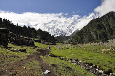
Nanga Parbat is the second highest mountain of
Pakistan and ninth highest in the world. It in not part of the Karakoram as it
is the western extremity of the mighty Himalaya. It is separated from the
Karakoram by the mighty Indus River. Nanga Parbat, Sanskrit for “Naked
Mountain” is so named because some of its slopes are so steep that they are
bereft of vegetation and snow. According to the local old legend, Nanga Parbat is
also called Diamir, which means abode of fairies. It is believed that the Queen
of fairies lives there in a castle made of solid crystal-clear ice, which is
guarded by gigantic snow serpents and frogs. Nanga Parbat is not a single peak
but consists of 20km long series of peaks and ridges culminating in an ice
crest of (8125m).
Its South Face known as Rupal Face is (5000m) high,
while the North or Raikot Face plunging over (7000m) from the summit to the
Indus forms one of the world’s deepest gorge. This expedition takes us to the
West Side, which is known as Diamir Face.
Because of the 2013 shootings in “fairy meadows”
we will choose to climb Nanga Parbat from the Rupal Face this time; Here Base
Camp is a safe place frequently patrolled by Amry and Police. The route we
follow will be the Hanns Schell route; this is the easiest slightly
longer route on the Rupal Face. This expedition is a collaboration between some
mayor expedition outfitters; we will follow the same strategic as on our 100% successful
K2 expeditions in 2012 & 2014; this will ensure us enough manpower on the
mountain!


No comments:
Post a Comment